

Introducing Pasco SiteView
 Nigel 8 Mar 2026 4 min read
Construction sites generate enormous amounts of spatial data — drone flights, survey points, elevation models, progress photos. Until now, making sense of that data meant juggling expensive SaaS platforms, exporting files between tools, and hoping everyone was looking at the same version of the truth.
Today we're introducing SiteView, a new application in the Pasco Cloud ecosystem purpose-built for construction site mapping, drone survey management, and interactive 3D measurement.
What SiteView Does
SiteView gives construction teams a single place to manage their site survey data and take measurements directly on a 3D map. The core workflow is straightforward:
- Fly your drone over the construction site, capturing overlapping geotagged photos.
- Upload the images to SiteView and kick off processing. The photogrammetry engine produces orthophotos, point clouds, digital elevation models, and 3D meshes from your raw images.
- View your site in 3D — zoom from a global overview down to individual sites, with your drone imagery draped over the terrain at centimetre-level resolution.
- Measure anything — distance, area, volume, and elevation profiles directly on your survey data. No need to export to CAD software for basic measurements.
- Track progress — compare surveys over time with split-screen comparison to see what's changed on site.
Built on a 3D Globe
SiteView is powered by CesiumJS, the same 3D globe engine used by NASA, USGS, and defence organisations worldwide. You navigate a full 3D globe, zoom from a world view down to your construction sites, and interact with survey data in its real-world geographic context.
The globe supports multiple base map layers — OpenStreetMap for street context, satellite imagery for aerial context, and your own drone orthophotos at the highest zoom levels. At site level, your drone data provides 2-5 cm per pixel resolution, far exceeding any satellite provider.
Four Measurement Tools
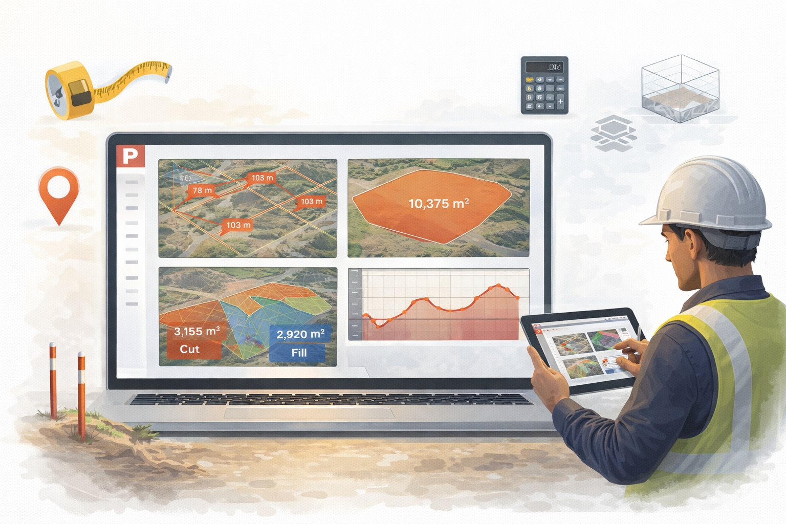 SiteView ships with four interactive measurement tools that work directly on your survey data:
- Distance — Click points on the map to measure polyline distances with per-segment breakdown. Uses geodesic calculations for accuracy over any distance.
- Area — Draw a polygon to calculate the enclosed area. Useful for slab pours, landscaping zones, and coverage calculations.
- Volume — Draw a polygon, set a reference elevation, and calculate cut and fill volumes from the digital elevation model. Essential for earthworks tracking.
- Elevation Profile — Draw a line across the site and see an interactive elevation chart showing the terrain cross-section. Useful for checking grades, drainage, and road profiles.
All measurements are saved to your site and can be revisited, renamed, and compared over time.
Part of Pasco Cloud
SiteView isn't a standalone tool — it's integrated into the Pasco Cloud platform. You log in with your existing Pasco account, and your sites live alongside your projects, reports, and issues. This means your survey data sits in the same ecosystem as your inspection reports, safety issues, and task management.
Over time, we'll deepen this integration — linking survey measurements to inspection reports, overlaying design surfaces against as-built surveys, and bringing site mapping data into your daily construction workflows.
What's Next
SiteView is in active development. The foundation is solid — site management, globe navigation, drone processing, and measurement tools are all working. Coming up:
- Design surface overlays — Upload DXF and KML files to compare your as-built survey against the engineering design. This is the feature that transforms SiteView from "what does my site look like today" into "how does my site compare to the plan."
- Annotations and markup — Drop pins, draw shapes, and attach notes to map locations for field communication.
- Cross-sections — Generate cross-section charts comparing survey data against design surfaces along any alignment.
- Report generation — Export PDF reports with site maps, measurements, and progress comparisons.
We're building SiteView for the people who actually run construction sites — superintendents, project managers, site engineers, and survey teams. If you have feedback or feature requests, we'd love to hear from you via the contact form.
SiteView is available now at siteview.pasco.cloud for all Pasco Cloud users.